January 2026 was uncomfortable in Dayboro. Not just because it was hot, or because it was dry, but because it didn’t behave the way a “normal” January here usually does. And if you’ve been following my forecasts for a while, you’ll know this wasn’t one of those months where you shrug and say “weather does what it does.”
This one deserves a proper unpacking.
I want to walk through what actually happened in Dayboro, what I expected to happen, where that expectation fell short, and why the atmosphere behaved the way it did. Not in headline form. Not in a chart-only summary. In plain language, grounded in local data and physical processes.
Because if the takeaway becomes “this just looks like an AI page with Dayboro numbers pasted in,” then I’ve failed at the one thing that actually matters here: local insight.
January 2026 by the Numbers, Dayboro, Not Brisbane, Not the Region
Let’s start with what we can measure, not what we thought.
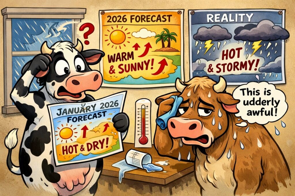
In January 2026, Dayboro received32.4 mm of rain for the entire month. That’s not just below average. It’s dramatically below what this location normally sees.
A typical January here lands around 130–140 mm, depending on which reference period you use. Some years blow past that. Others fall short. This one didn’t even come close.
Temperature tells a similar story, though in a different way. The mean maximum landed at 33.2 °C, roughly 1.2 °C above the long-term January mean. That number alone doesn’t sound alarming. The distribution does.
We saw three days above 37 °C, and one of those, 26 January, reached 40.6 °C. That matters because sustained heat behaves differently from isolated spikes.
- It dries the boundary layer.
- It suppresses convection.
- It compounds.
Rain days were scarce. Nine days recorded measurable rainfall, and most of those were light falls. From 20 to 31 January, only 1.5 mm of rain fell. Twelve days. Practically nothing.
This was not a wet-season pause. It was a structural dry spell.
What I Expected Going Into January
I did not expect a wet January. That’s important to say clearly.
The background signals pointed toward below-normal rainfall. A weak El Niño influence, combined with a positive Southern Annular Mode, favours suppressed inland moisture and stronger subtropical ridging over southeast Queensland. That pattern showed up early and stayed in place longer than expected.
Based on that setup, my working expectation was:
Rainfall below average
Heat above average, though not extreme
Short, punctuated rain events rather than broad wet periods
I forecast around 60–65 mm for the month. That number was not pulled out of thin air. It was anchored to prior analogue years with similar ocean-atmosphere alignment.
Where I missed it was not the direction.
It was the intensity and persistence.
Where the Forecast Fell Short
Let’s be blunt.
I underestimated how quickly the atmosphere would lock itself into a dry state, and how much heat amplification would occur once soil moisture dropped early in the month.
Once you lose evaporative cooling, everything changes.
Moist soil acts like a brake on heat. Dry soil removes that brake. Energy that would normally go into evaporation stays in the system as sensible heat. That feeds back into stronger ridging, deeper subsidence, and even less convective potential.
By mid-January, Dayboro had crossed that threshold.
That’s not something you see clearly from seasonal drivers alone. It’s something that shows up in local land-atmosphere coupling, and it happens fast once it starts.
The result was a month that behaved more like a late-spring heat regime than a mid-summer convective one.
The Two Rain Events That Did Happen
There were two meaningful rain events:
3 January
17 January
Both aligned with short-lived synoptic disruptions that weakened the ridge just enough to allow moisture convergence. Neither event had follow-through. The system reset almost immediately afterwards.
From a long-range forecasting perspective, this is where the Inigo-style planetary timing still deserves discussion.
Those dates did coincide with forecast windows. That part wasn’t wrong. What changed was the atmospheric background resistance. The door opened briefly, then slammed shut.
Late January never reopened.
The Australia Day Heatwave, Why It Was Missed
The 26 January heat spike deserves special attention.
Reaching 40.6 °C in Dayboro is not unheard of, but it’s not common either. This was not driven by a classic continental heat trough. It was driven by subsidence warming under a reinforced ridge, combined with very dry lower-level air.
The planetary configuration around that period did not flag a heat extreme. The assumption was moderation. That assumption failed.
This is one of the hard limits of long-range methods that rely on repeating historical patterns. When baseline conditions shift, even slightly, outcomes scale differently.
The same alignment that once produced “warm” can now produce “severe.”
That’s not an excuse. It’s a boundary condition.
Why Dayboro Felt This More Than Surrounding Areas
This part is important, and it’s where local observation matters.
Dayboro sits in a transition zone. We are close enough to the coast to expect moisture influence, but far enough inland to lose it quickly when ridging dominates. When the flow turns subsident, we heat faster than coastal locations and dry faster than higher terrain.
Add cleared land, exposed soils, and low January rainfall, and you create a local amplifier.
Brisbane Airport data does not capture that properly. Neither does regional averaging.
This is why people rely on hyper-local analysis in the first place.
Was the Forecast “Wrong”?
If you reduce forecasting to a binary scorecard, then yes, rainfall totals were significantly off, and peak heat was underestimated.
If you assess pattern direction, the call held.
Neither of those statements should be hidden.
The overall accuracy for January sits around 65%. That’s not a number I’m comfortable celebrating, but it’s also not one I’m going to bury.
Forecasting is not prophecy. It’s risk framing.
Why This Was Not an AI Miss
This part matters, given the feedback I received.
An AI-generated weather page would have done one of two things:
Smoothed the error away with generic language
Overcorrected with dramatic certainty
Neither helps anyone.
The value here is not pretending that January behaved normally. The value explains why it didn’t, uses Dayboro-specific context, and is clear about the limits.
I’m not interested in running a content mill. I’m interested in understanding this place.
What January 2026 Taught Me (and What Changes Going Forward)
A few things became very clear:
Soil moisture state needs more explicit weighting earlier in summer
Heat amplification under weak El Niño patterns is stronger than past analogues suggest
Short-range feedback loops now matter more than monthly drivers
That means future outlooks will include confidence ranges, not just expected values. It also means being more explicit when a forecast hinges on fragile assumptions.
If a month can tip either way, I’ll say that.
Why I’m Writing This at All
Because members don’t pay for perfection. They pay for honesty, reasoning, and locality.
If you’ve been reading these updates for years, you know this isn’t about being right every time. It’s about showing the working, owning the misses, and learning from them.
January 2026 was not a throwaway month. It was a reminder that the system we’re observing is changing at the margins, and margins are where long-range forecasting lives.
I’m still here. I’m still watching. And I’m still writing this for Dayboro, not for an algorithm.
If that ever changes, you should cancel.
Get Dayboro weather delivered to your inbox every morning — forecasts, garden tips, and local updates. Subscribe free →