Why Dayboro’s Custom Weather Reports are a Must-Have for Locals
In Dayboro, where our sunny skies and lush landscapes inspire outdoor adventures, staying ahead of the weather is key. Whether you’re planning a barbecue, organizing a community event, or simply deciding what to wear, having up-to-date weather reports tailored for Dayboro makes all the difference. That’s why our exclusive email weather updates are here to help you stay one step ahead, delivered straight to your inbox at your preferred time.
The Unique Challenges of Dayboro Weather
Dayboro’s location and climate present a unique blend of beauty and unpredictability. Nestled in the Moreton Bay Region of Queensland, just 45 km northwest of Brisbane, Dayboro boasts a humid subtropical climate. This type of climate means hot and humid summers contrasted with mild and dry winters. While this weather pattern makes Dayboro a paradise for nature lovers, it also presents challenges, especially for backyard growers. (Best use the Dayboro Veggie Guide)
The average annual rainfall in Dayboro is 1130.6 mm, with most of the rain falling between November and March. January is typically the wettest month, with an average of 184.9 mm. However, the surrounding D’Aguilar Range creates microclimates that can lead to sudden weather shifts. From unexpected rain showers to heat waves, standard weather apps often miss these localised conditions.
Our custom weather reports come in because general weather apps are not considering our “Dayboro Dome”. By focusing specifically on Dayboro’s unique geographical and climatic conditions, these reports provide unparalleled accuracy and relevance for residents. Whether it’s the moderating effects of the sea breeze or the heat waves that roll in when it weakens, our weather updates keep you informed about the factors that truly matter to your day.
Tailored Weather Updates: Why They’re Worth It
Unlike general weather forecasts, our reports are designed with Dayboro residents in mind. Here’s why they stand out:
Hyper-Local Accuracy
Standard weather services often rely on data from Brisbane or nearby urban areas. While helpful, these forecasts don’t always reflect the unique weather patterns of Dayboro. Our reports factor in local influences like the D’Aguilar Range’s rain shadow effect, ensuring you receive precise predictions tailored to our community.
For example, Dayboro’s proximity to the mountains in summer can lead to cooler mornings and hotter afternoons than coastal regions. Knowing this can make or break plans for outdoor activities like hiking or gardening.

Timely and Actionable Insights
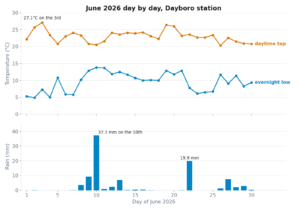
Timing is everything when it comes to weather. That’s why our reports are created every three hours, giving you the most current information to help plan your day. You can choose from updates at 4 am, 7 am, 10 am, 1 pm, 4 pm, 7 pm, and 10 pm, delivered straight to your inbox.
Need to know if a storm is rolling in before your afternoon picnic? Want to ensure your kids’ soccer practice won’t get rained out? With our tailored reports, you’ll have the information you need when you need it most. Also, our standard warning messages (active on m8chat.au by the end of February) will provide real-time weather warnings.
Adaptable to Your Schedule
We understand that everyone’s day runs on a different clock. That’s why we’ve made it easy to customize your email preferences. Whether you’re an early riser who checks the weather at 7 am or plan evening activities based on a 4 pm update, you can select the best times. This flexibility ensures you stay informed without being overwhelmed.
The Impact of Weather on Dayboro Life
Dayboro’s weather plays a significant role in shaping our community’s daily life and activities. Everyone benefits from staying informed about upcoming weather conditions, from farmers to festival organisers. Here are just a few examples:
Supporting Local Farmers
Agriculture is a vital part of Dayboro’s identity. Knowing when rain is expected or when temperatures will spike helps local farmers make critical decisions about irrigation, planting, and harvesting. By subscribing to our weather updates, you’re not just staying informed, you’re joining a network of residents who value and support our agricultural community.
Enhancing Outdoor Events
Dayboro’s vibrant community spirit is showcased through events like the Dayboro Day Festival, local markets, and outdoor concerts. Accurate weather predictions ensure these events run smoothly, helping organizers prepare for potential rain or heat waves.
Safeguarding Against Severe Weather
Queensland’s storm season is no joke, and Dayboro is no exception. Severe storms can bring heavy rain, strong winds, and even bushfire risks. Our reports include warnings about these conditions, giving you the time to prepare and stay safe.
How to Subscribe to Custom Weather Reports
Getting started is simple. Here’s how you can sign up for our tailored weather updates:
Visit your Dashboard: Navigate to About us –> Membership Dashboard
Select email reports: Select from the seven daily updates. You can opt for all or just a few.
Enter Your Email Address: Ensure you provide a valid email address to receive updates without interruption.
Save Your Preferences: Click “Save Preferences,” and you’re all set!
Once subscribed, you’ll receive timely, detailed weather reports crafted specifically for Dayboro. It’s that easy.
What’s in a Weather Report?
Each report provides:
Clear Descriptions: Understand what to expect with straightforward, jargon-free language.
Hourly Updates: See how the weather will evolve throughout the day.
Actionable Advice: Get insights on preparing for rain, heat, or storms.
Community Relevance: Stay informed about conditions that impact Dayboro specifically, like bushfire risks or localized rain.
_______________________________________________________________________________

Tonight: Mostly cloudy in the evening, becoming partly cloudy after midnight.
Patchy light fog after midnight. A chance of rain. Low 18. Wind north around 8 kph, gusting to 32 kph, in the evening, becoming west around 3 kph after midnight. Chance of precipitation 30 percent. Precipitation mostly less than 2 mm.

Saturday (18 Jan): Partly to mostly sunny in the morning, becoming partly to mostly cloudy in the afternoon. High 31. UV index up to 11. Wind south-southwest around 5 kph in the morning, becoming southeast in the afternoon.

Saturday night: Fair to partly cloudy in the evening, becoming partly to mostly cloudy after midnight. Patchy light fog in the evening, then moderate fog after midnight. A slight chance of rain in the evening, then a chance of rain after midnight. Low 17. Wind south-southeast around 8 kph. Chance of precipitation 40 percent. Precipitation mostly around 2 mm.

Sunday (19 Jan): Partly to mostly sunny. Moderate fog in the morning. High 28.
UV index up to 12. Wind south-southeast around 17 kph, gusting to 33 kph.

Sunday night: Fair in the evening, becoming mostly clear after midnight. Patchy light fog after midnight. Relatively cool. Low 17. Wind south around 10 kph, gusting to 27 kph, in the evening, becoming 4 kph after midnight.

Monday (20 Jan): Sunny in the morning, becoming mostly cloudy in the afternoon.
High 31. UV index up to 13. Wind south around 7 kph in the morning, becoming east in the afternoon.

Monday night: Cloudy in the evening, becoming mostly cloudy after midnight. Low 19. Wind east around 3 kph in the evening, becoming west after midnight.

Tuesday (21 Jan): Mostly sunny in the morning, becoming partly to mostly cloudy in the afternoon. High 34. UV index up to 11. Wind west-northwest around 5 kph in the morning, becoming east-northeast in the afternoon.

Tuesday night: Partly cloudy in the evening, becoming fair after midnight. Low 19. Wind east-northeast around 3 kph in the evening, becoming north-northwest after midnight.

Wednesday (22 Jan): Sunny in the morning, becoming partly cloudy in the afternoon. Hot. High 37. UV index up to 12. Wind west-northwest around 6 kph in the morning, becoming north-northwest in the afternoon.

Wednesday night: Fair to partly cloudy in the evening, becoming clear after midnight. Light to moderate fog after midnight. Low 19. Wind north around 4 kph in the evening, becoming west-northwest after midnight.

Thursday (23 Jan): Sunny in the morning, becoming partly cloudy in the afternoon. Patchy light fog in the morning. Hot. High 38. Heat index up to 40.
UV index up to 13. Wind west-northwest around 7 kph in the morning, becoming north-northeast in the afternoon.

Thursday night: Mostly cloudy to cloudy in the evening, becoming cloudy after midnight. A slight chance of rain. Scattered thundershowers possible. Low 23.
Wind north-northeast around 4 kph. Chance of precipitation 20 percent.
Precipitation mostly less than 2 mm.

Friday (24 Jan): Cloudy. Light to moderate fog in the afternoon. A slight chance of rain in the morning, then rain likely in the afternoon. Scattered thunderstorms likely. High 33. Heat index up to 37. UV index up to 8. Wind north-northwest around 10 kph. Chance of precipitation 70 percent. Precipitation mostly around 10 mm.

Friday night: Mostly cloudy to cloudy in the evening, becoming cloudy after midnight. Moderate fog in the evening, then patchy light fog after midnight. A chance of rain in the evening, then a slight chance of rain after midnight.
Scattered thundershowers possible. Low 24. Wind south-southeast around 6 kph.
Chance of precipitation 40 percent. Precipitation mostly less than 2 mm.

Saturday (25 Jan): Mostly cloudy to cloudy in the morning, becoming mostly cloudy in the afternoon. Patchy light fog in the morning. A slight chance of rain. Precipitation showery or intermittent. High 30. UV index up to 8. Wind east-southeast around 7 kph. Chance of precipitation 20 percent. Precipitation mostly less than 2 mm.

Saturday night: Partly cloudy. Patchy light fog in the evening, then light to moderate fog after midnight. Low 21. Wind east-northeast near calm in the evening, becoming southwest after midnight.

* THIS FORECAST WAS MADE IN AUTOMATED MODE AND MAY BE LESS ACCURATE THAN OTHERWISE *
Community Benefits of Staying Informed
Our custom weather reports aren’t just about convenience and building a stronger, more connected Dayboro. Here’s how:
Promoting Safety
Weather can be unpredictable, especially during storm season. You can take proactive steps to protect your family, property, and community by staying informed. From securing outdoor furniture before a windstorm to preparing emergency kits, timely updates make all the difference.
Why Subscribe?
Still on the fence? Here are a few more reasons to join our growing community of subscribers:
Peace of Mind: No more guessing or relying on generic apps. Our reports give you the confidence to plan your day with ease.
Local Focus: By subscribing, you support a service prioritising Dayboro and its unique needs.
Enhanced Living: These updates improve your quality of life, from better outdoor plans to safer responses during severe weather.
Support: It helps us run this service. If equipment breaks or sensors expire, your subscription will help us replace them. Since 2004, we have provided free weather updates and forecasts online. However, as the equipment expires due to old age, we require funds to replace it.
Get Dayboro weather delivered to your inbox every morning — forecasts, garden tips, and local updates. Subscribe free →