
The Quiet Revision, Part Two: The Worst Case Climate Scenario Just Got Cut Again
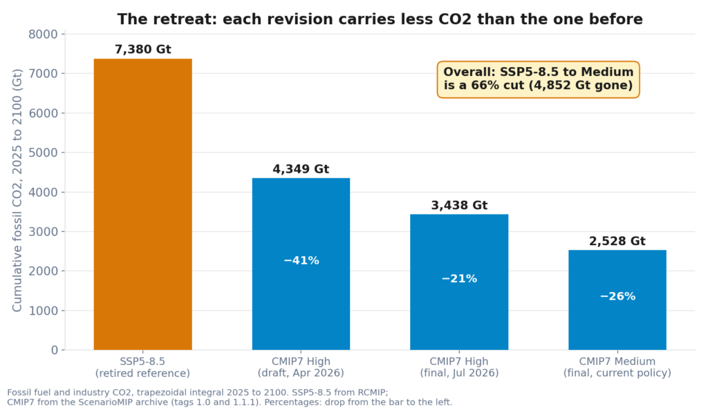
In April the climate science community quietly retired its most cited worst case scenario. This month the final CMIP7 numbers landed and they cut the projections again. We pulled the data apart and found something odd on the way through: the CO2 went down, and the projected warming went up.
Strongest El Nino in 75 Years? We Checked Every Number in the Headline

A claim by claim verification of the July 2026 super El Nino headlines against raw NOAA CPC weekly data, the Bureau of Meteorology SOI archive, multi model forecasts and a twenty year Dayboro rain gauge record. The packaging is hype. The ocean is not.
Dayboro show Weather

The Dayboro Show is on 4–5 July 2026 at the Showgrounds. Our Dayboro Model and the Bureau both call sunny and dry, tops near 24°C with cold foggy starts. Pack a jacket for the morning, sunscreen for the middle.
Super El Nino 2026/27: Is This 1877 Again, and What Does It Mean for Dayboro?
A data-grounded look at whether the 2026 super El Nino really echoes the catastrophic 1877 event, testing the ocean, sunspot, planetary and Indian Ocean Dipole evidence, with consequences for southeast Queensland and a grow-your-own resilience message.
Prose versus Table, I did it wrong.

I tend to confuse myself at the best of days, and as it so happens… I buggered it up yet again. The website was reading the information from the prose it produces, instead of reading it from the model table.
Autumn 2026

What was the weather in Autumn 2026
Day picker added to both calculators

The Spray Window Calculator and Solar Calculator now step through the full Dayboro Model week-ahead forecast. Pick any day, see conditions for that day. Member feature.
The Quiet Revision: How Climate Scientists Removed Their Most Cited Scenario, and What It Reveals About Scientific Consensus

CMIP7’s new scenario framework formally labels SSP5-8.5, the worst-case projection used in thousands of climate studies, as implausible. Examines what the revision changes, what it doesn’t, and what the 97% consensus actually measured.
el-nino 2026 for Dayboro
International forecast models now show strong consensus on El Niño development between May and July 2026. This paper analyses what that means for Dayboro.
Fire danger 2026

20 years of Lyndhurst Hill weather data + BoM seasonal outlook, read for a Dayboro property owner. What the numbers actually show and what’s worth doing.