
The Week Ahead
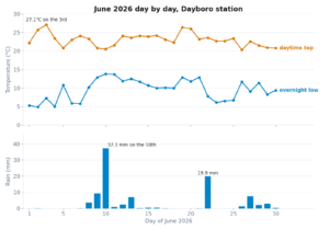
The station is reading 8.5°C this morning, with today’s range sitting at 8.3–11.4°C and no rain recorded yet. That pretty much sums up where we are in the seasonal cycle. Cold mornings, mild afternoons, and a week that starts cloudy before a winter high clears things out nicely.
Monday carries a 30% chance of a shower, with cloud hanging over the ranges through the day. A weak trough is the likely culprit, dragging moisture across from the coast. After that, a broad high pressure system takes over and pushes the cloud away. Tuesday gets back to mostly sunny, and Wednesday is shaping up as a proper blue-sky July day with a high of 22°C. The catch is overnight lows. Tuesday night looks particularly sharp, with the Dayboro Model calling 6°C. If you have frost-sensitive plants in the garden, keep an eye on that.
Day-by-Day Forecast
| Day | Date | Min | Max | Rain Chance | Outlook |
|---|---|---|---|---|---|
| Monday | 29 Jun | 9°C | 20°C | 30% | Mostly cloudy, slight chance of rain |
| Tuesday | 30 Jun | 6°C | 20°C | 10% | Cloudy morning, clearing to mostly sunny |
| Wednesday | 1 Jul | 12°C | 22°C | 0% | Sunny |
How the Models Have Been Tracking
The Dayboro Model is still accumulating its 30-day dataset, so I don’t have composite accuracy scores to report for it yet. On the BOM side, the recent numbers are solid. Over the past 30 days, BOM has scored 77.1% on its overall forecast composite and a strong 95.3% on temperature accuracy. The temperature result makes sense for this time of year. Winter in SE Queensland is largely driven by well-defined high pressure systems, and those are more predictable than the chaotic storm systems we deal with in summer. Rain calls are always the harder part of the job. Once the Dayboro Model has enough data behind it, the comparison between the two will be worth a proper look.
What’s Happening Across the Region
This pattern is textbook mid-winter for SE Queensland. A trough brings cloud and a touch of rain to start the week, a high moves in, and the back half turns dry and sunny. It’s the same story up and down the coast this week. Brisbane and the Gold Coast are tracking at similar daytime highs to Dayboro, averaging around 20–21°C. Our position in the D’Aguilar Range foothills means our overnight lows run a degree or two cooler than the coastal plain. That shows in the numbers. The broader SE QLD region is averaging a weekly minimum of 12.1°C, while Dayboro sits at 11.7°C.
Further north, Cairns and the Wet Tropics are carrying a 27% average rain probability across the week. That’s the dry season taking hold on schedule. Darwin is properly dry now, as you’d expect for early July in the Top End.
Garden and Outdoor Tip
Three things are on high alert right now: snails and slugs, late blight, and downy mildew. Monday’s cloud and overnight dampness are exactly the conditions these problems love. If you’ve been putting off laying snail bait, do it today. Check your tomatoes, potatoes, and brassicas for early signs of blight or mildew. Once Tuesday and Wednesday turn sunny, get out and thin any dense foliage to improve airflow around your plants. Good air circulation is one of the best defences against fungal disease, and you’ll have two calm, dry days to do the job properly.
Want the full extended outlook delivered to your inbox each week? Sign up for free email updates from the Dayboro weather station.
The 4-day extended forecast is for members only
Members get the full 7-day outlook, rain probability detail, Inigo Jones long-range commentary, and an ad-free experience.
Get Dayboro weather delivered to your inbox every morning — forecasts, garden tips, and local updates. Subscribe free →