
Autumn 2026: What the Valley Is Telling Us
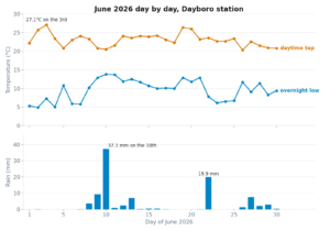
March gave us 252mm, a 78mm/hr storm, and a 10°C overnight that caught half the valley off guard. Then April showed up and basically forgot to rain. Nine days in, we've had 6.3mm — most of that probably dew on the sensor.
So which version of autumn are we getting? The wet one or the dry one?
I've been watching this valley form Lyndhurst Hill since 2004. I've got 13 years of solid station data, an Inigo Jones forecast pipeline running daily, and a Dayboro Model that updates every morning. Here's what all three are saying about the rest of the season.
What March Already Told Us
If you missed the full March review, the short version: March 2026 was the coolest March in five years, averaging 22.7°C against a 2022–2025 range of 23.2–24.6°C. The 10.0°C minimum on the 28th was the lowest March overnight we've recorded since 2008. Almost all the rain fell in the first fortnight — 136mm in a single two day event on the 8th and 9th alone.
Crucially, rainfall was near the long term March average of 260mm. Not extreme, despite what it felt like when Lacey's Creek Rd went under. Last year March dumped 767mm. The year before, 236mm. March in this valley is nothing if not volatile.
Where April Stands — and Where It's Heading
Right now, 9 April, we've recorded 6.3mm for the month. The long term April average is 150mm. To put that in perspective: the driest complete April in my records was 41.1mm in 2022. Even that was seven times what I've had so far.
My Dayboro Model shows zero rain in the next eight days. Morning fog, temperatures pushing 31–32°C, UV index sitting at 8 (very high). That doesn't feel like mid autumn to me. More like late summer refusing to leave.
What Inigo Jones says about April
My Inigo Jones forecast for April calls for near average rainfall of about 117mm, with most of it arriving in the second half of the month. My daily breakdown shows a wetter window around 20–21 April (probability of precipitation hitting 50–55%), then drying out again through the last week. Temperatures are forecast cooler than average: maximums around 25–27°C, minimums dropping to 13–14°C.
If that mid month rain comes through, we coudl still end up near 80–100mm for April. That woudl be below average, but not dramatically so. The 2021–2024 April range is 41–152mm, so I reckon there's a lot of room to land in.
The Full Autumn Picture
Here's what autumn has looked like over the past five years, and where 2026 is tracking.
| Year | March | April | May | Autumn Total |
|---|---|---|---|---|
| 2021 | 259mm | 152mm | 119mm | 530mm |
| 2022 | 117mm | 41mm | 304mm | 461mm |
| 2023 | 156mm | 56mm | 117mm | 329mm |
| 2024 | 236mm | 114mm | 66mm | 416mm |
| 2025 | 767mm | 246mm | 114mm | 1,127mm |
| 2026 | 252mm | 6mm* | TBD | ~470mm est. |
* April 2026 figure is to 9 April only. Estimate based on Inigo Jones forecast for remainder of April (~117mm) and May (~95mm).
The long term autumn average from my 13 complete years of data is 561mm. My Inigo Jones pipeline forecasts roughly 117mm for April and 95mm for May. Add March's 252mm and I get an estimated autumn total around 470mm — about 16% below the long term average, but well within the normal range (329–530mm, excluding the 2025 outlier).
What the Climate Drivers Are Doing
Three indices shape our autumn weather up here. All three are currently in a moderate position — no extreme signals either way.
ENSO (ONI: −0.39)
IOD: +0.5
The positive IOD is the one to watch. When the IOD goes positive, it typically dries out the eastern seaboard. It's not a guarantee — local dynamics and coastal troughs can override it — but it does tip the probability toward a drier finish to autumn. In the begin of April we're already seeing that play out.
Temperature Outlook: Cooling Down, But Not Fast
March 2026 averaged 22.7°C. The first nine days of April are averaging 21.6°C. That's a gentle decline, but we're still running warm — the 8 April maximum hit 34.9°C, which is remarkable for mid April.
| Period | Forecast Max | Forecast Min | Source |
|---|---|---|---|
| 9–16 April | 29–32°C | 13–16°C | Dayboro Model |
| 17–30 April | 25–27°C | 13–14°C | Inigo Jones |
| May | 22–25°C | 9–12°C | Inigo Jones |
My takeaway: expect a sharp step down in temperatures when the pattern finally shifts around mid to-late April. My Dayboro Model shows 29–32°C this week. By late April, Inigo has us back down to 25–27°C maximums. I expect May to drop further — overnight lows below 10°C become likely, and the monthly average minimum is forecast at 9.4°C.
If you've still got tropical plants outdoors in pots, now is the time to think about moving them somewhere sheltered. Not next month. Now.
What This Means for the Garden
Autumn growing window: it's shorter than you think
Right now the soil is warm (mid-20s at 10cm depth) and the days are long enough for most cool season crops to establish. But that window closes fast. By mid May, soil temperatures will be below 15°C and growth rates halve for most vegetables.
Plant this week, not next month: Brassicas (broccoli, cauliflower, cabbage), leafy greens (lettuce, spinach, silverbeet), root vegetables (beetroot, carrots, turnips), and herbs (coriander, parsley). They all want to be in the ground before the overnight lows consistently drop below 12°C.
Hold off on: Tomatoes, capsicums, beans, and anything tropical. Their season is over. Let them go gracefully.
If you're serious about getting the most out of this autumn window, Garden Buddy's Seed to Plate email is worth a look. It's a morning email that knows what you've planted and cross references today's actual weather from the station — not some generic gardening calendar written for Sydney. It'll tell you what to water, what to watch, and when your specific crops are ready to harvest. Think of it as the weather forecast, but for your garden beds specifically.
Vegetable Prices: Why Your Garden Matters More Than Usual
Here's the practical angle. Supermarket vegetable prices have been climbing, and the outlook for the next few months isn't great. Our April 2026 vegetable price outlook breaks down the numbers, but the short version: supply disruptions from last year's wet season are still working through the chain, and a drier autumn means less production from the Lockyer Valley and Scenic Rim growing regions that supply most of Brisbane's fresh produce.
A head of broccoli that cost $3.50 in January is already pushing $5 in some stores. Leafy greens are volatile. Root vegetables are the most stable, which is convenient because they're also the easiest thing to grow in a Dayboro autumn.
Rainfall Forecast: Where the Rest of the Rain Is
Based on the Inigo Jones pipeline (updated daily, confidence: moderate) and the Dayboro Model (8-day high resolution):
April Remainder
May
If my numbers hold, April finishes around 115–120mm (including the 6.3mm already recorded) and May adds another 95mm. The autumn total lands around 460–470mm — a bit below average, but nothing that should cause alarm for tanks or dams. I reckon the soil moisture reserves from March's 252mm are still in the system.
The real risk is timing. If the mid April rain window misses us — and it's not guaranteed; the probability of precipitation on those days is only 50–55% — then April could eventually finish well below 80mm and we'd be looking at a really dry autumn. Keep an eye on the forecast accuracy dashboard to see how these predictions are tracking against reality.
For Farmers and Growers
Irrigation
The next week is hot and bone dry. If you've got new plantings in the ground, they'll need daily water. Those seedlings are waiting on the hose, not the sky. The UV index is sitting at 8 — that's evaporation rates more typical of February than April. Don't assume autumn means you can back off the hose.
Hay timing
The dry window through 16 April is excellent for cutting and baling if you've got standing grass. After that, the Inigo Jones forecast suggests a wetter patch in the weekend of the 20th. If you're waiting for a better window, this might be it.
Frost preparation
May minimums are forecast at 9.4°C average, with some mornings potentially dropping below 8°C. First frost risk on the ridge is typically late May to early June, but March already gave us 10°C on the 28th. If you're growing anything frost sensitive on an exposed slope, start planning your protection strategy now. Control the dew point readings on your own low spot before you commit.
Garden Buddy tracks your specific plants against today's actual Dayboro weather. Morning emails, personalised to your patch. It's the gardening advice you wished your neighbour would give you — except it's backed by real data from the station on the hill.
Try Garden BuddyThe Bottom Line
In my view, autumn 2026 is shaping up as a story of two halves — a wet March and a drier April–May. The Inigo Jones cycles I run, the positive IOD, and the ENSO neutral state all point in the same direction: below average rainfall for the rest of the season, but not a drought. Temperatures will drop noticeably from mid April, with proper cold mornings arriving in May.
For gardeners: I'd plant your cool season crops now. Not next week. Now. The soil is warm, the days are still long enough, and by mid May the window has closed. If you want help knowing exactly what to do each morning, Garden Buddy's Seed to Plate email takes the guesswork out of it.
For farmers: I'd use this dry window. Cut hay, fix fences, service irrigation. The rain that's coming later this month probably won't be heavy enough to cause problems, but it will interrupt outdoor work.
And for everyone watching the grocery bill: vegetable prices are heading up. In my experience a backyard garden in Dayboro has always been a good idea. This autumn, I reckon it's an even better one.
Data Sources & Methodology
Station data: Dayboro Weather Station, Lyndhurst Hill (27.18°S, 152.83°E, 72m elevation). Ecowitt GW2000 + WS90 sensor suite. Data archive from 2005 to present via WeeWX/MariaDB. 5-minute polling interval.
Dayboro Model: WXSIM numerical weather prediction model calibrated for Dayboro's microclimate. Updated daily at 06:00 AEST. 8-day high resolution forecast.
Inigo Jones forecast: Long range analogue method using planetary and lunar cycle multipliers (Bruckner 35-year, Jupiter 12-year, solar, Saturn, Venus cycles). Monthly and daily forecasts generated from historical climatology shaped by current cycle positions. 30-day rolling forecast updated daily at 03:00 AEST. Confidence rating for April–May: moderate (0.35).
Climate drivers: ENSO ONI −0.39 (neutral), IOD +0.5 (positive), SAM +8.0 (positive). Source: Inigo Jones forecast pipeline.
Rainfall history: 13 complete autumn periods (March–May) from 2008–2016 and 2021–2025. Long term autumn average: 561mm.
All figures are from the Dayboro Weather Station unless otherwise noted. Forecasts are estimates, not guarantees. Your property's rainfall may differ from the station — elevation, aspect and distance from the range all matter up here.
Get Dayboro weather delivered to your inbox every morning — forecasts, garden tips, and local updates. Subscribe free →